
 TerraScan
Check soil, flood zone and other ground layers
Turn on TerraScan's map layers for a property to see shrink-swell soil, flood zone, geology, drought and more.
The Layers panel shows what's in the ground and around the house. Turn a layer on to draw it on the map and see its details for the property.
Steps
- Open the property from Properties.
- In the Layers panel, pick a Basemap: Satellite, Streets or Terrain.
- Turn on the layers you want with their switches. Type in Search layers… to find one fast.
- Scroll down in the panel to read the detail card for each layer that's on, for example the elevation in feet or the soil's shrink-swell rating.
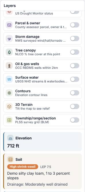
The layers
| Layer | What it tells you |
|---|---|
| Geology | The bedrock unit under the house. |
| Elevation | Ground elevation at the house. |
| Soil | The soil map unit and its shrink-swell risk. |
| Flood zone | The FEMA flood hazard zone. |
| Wetlands | Whether a mapped wetland is there. |
| Groundwater | Mapped aquifers under the property. |
| Seismicity | Earthquakes of magnitude 2.0 or more in the last 10 years. |
| Drought | The current US Drought Monitor status. |
| Parcel & owner | County parcel, owner and tax details, where the county publishes them. |
| Storm damage | Surveyed wind, hail and tornado damage. |
| Tree canopy | Percent tree cover at the house. |
| Oil & gas wells | Wells within 2 km. |
| Surface water | Streams and ponds within 2 km. |
| Contours, 3D Terrain, Township/range/section | Map aids for the lay of the land and the survey grid. |
Look at an area without a property
Click Map in the left menu. Search an address, town or ZIP, turn on layers under Layers ›, and click any spot to see What's here. Zoom in closer if a layer asks you to.
Related questions
A layer says "unavailable"
That source has no data for this spot, or it didn't answer. Try again later. The rest of the layers still work.
Why is the Basemap locked?
You can't switch the basemap while you're drawing a boundary, measuring or placing a site plan. Finish or cancel that first.
Thanks for letting us know.
Still need help?
Send us a message and a real person on the Terralox team will get back to you, usually the same business day.