
 TerraTopo
Save, export and compare surveys
Save surveys to your account, download the heatmap picture or survey file, and compare a new visit to an earlier one.
TerraTopo saves surveys to your company's account so anyone on the team can open them. You can also download the heatmap as a picture and compare a new visit to an earlier one.
Save and open projects
- Click Save to my account. If the project has no name yet, type the address when asked.
- Click My projects. Your company's jobs open full screen as address folders, one per house, the same as in every Terralox program. Search an address, a customer, a JobTread job number or a status.
- Tap a house's folder, then:
- Start a survey opens the house's survey. If it doesn't have one yet, a survey starts on its TerraPlan drawing (scale and house outline set), or in its JobTread job.
- On the Work tab, Open in TerraTopo opens a survey, Use as baseline compares the open survey against it, and Delete deletes it.
- New job asks for the address first. Load the plan in Step 1, add readings and Save: the survey is filed in that house's folder.
- ‹ Back to the survey closes My projects.
Download the heatmap picture
- Under 11. Export & save survey, fill in Project / address and Notes. They print in the corner of the picture with the date.
- Tick Include scale bar (requires Step 5) and Include orientation arrow if you want them.
- Click Download heatmap PNG. The picture downloads to your device, ready to email or put in a report.
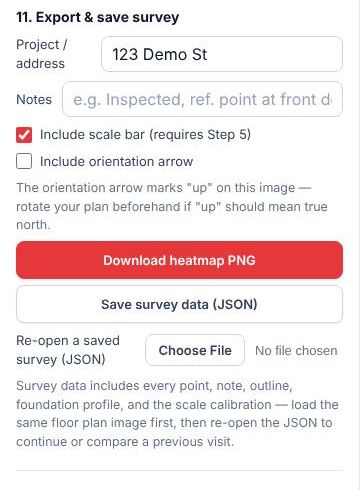
Save survey data (JSON) downloads the survey as a file, with every point, note, outline, the foundation profile and the scale. Load the same plan, then use Re-open a saved survey (JSON) to continue from it.
Compare to an earlier visit
- Open the earlier survey and click Save as copy (keep the original). Name it for the new visit, for example "123 Demo St – visit Oct 21". The original stays as it was.
- Update the readings for the new visit and save.
- Click My projects, open the house's folder, and on the Work tab click Use as baseline on the earlier visit. (The copy is filed in the same house's folder.)
- Show movement since baseline turns on. Set Flag movement greater than (in) to mark the spots that moved more than that.
You can also load a baseline from a file under 12. Compare to a previous survey.
Related questions
Does saving keep the plan picture?
Yes, when the plan file is 4 MB or less. Bigger plans save the survey only. See TerraTopo won't open my saved plan.
Thanks for letting us know.
Still need help?
Send us a message and a real person on the Terralox team will get back to you, usually the same business day.