
 TerraTopo
 overview
What TerraTopo is for, and how the numbered steps on the left and the heatmap on the right fit together.
TerraTopo turns a floor elevation survey into a color heatmap on the house plan. Load the plan, enter the readings from your zip level or laser, and TerraTopo shows where the floor is low, how steep the changes are, and where repairs would go.
Open it from your programs page or go to /terratopo/app.
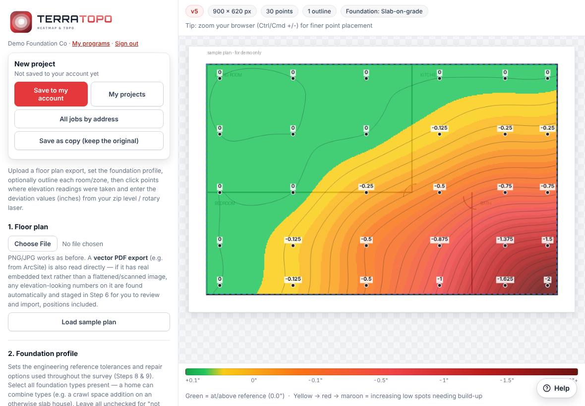
The screen
On the right is the plan with the heatmap. The badges along the top show the plan size, how many points and outlines you have, and the foundation type. The color bar along the bottom is the legend:
- Green is at or above your reference point (0.0").
- Yellow, red and maroon are lower and lower spots.
On the left are your account box and twelve numbered steps. The Terralox button at the top of that column (on a phone, at the left of the badges above the plan) goes to the terralox.com home page; tap the small arrow next to it for My account, Jobs, your other programs, the Help Center and Sign out. The TerraTopo logo goes to your programs page. Work down them in order. Most are optional.
| Step | What it does |
|---|---|
| 1. Floor plan | Load the plan picture or PDF. |
| 2. Foundation profile | Pick slab, crawl space or basement. Sets the tolerances and repair options. |
| 3. Click mode | Choose whether a click marks a point or draws an outline. |
| 4. Floor area outlines | Keep the heatmap inside the house. Add interior walls. |
| 5. Scale & auto-grid | Set the real-world scale and drop an even grid of points. |
| 6. Import readings | Paste a list of readings instead of typing each one. |
| 7. Elevation points | The list of every reading. |
| 8. Heatmap settings | Opacity, contour lines, steep transition areas. |
| 9. Structural diagnostics | Low-confidence shading, stress points and the repair layout. |
| 10. Statistics | Lowest, highest, average and range. |
| 11. Export & save survey | Download the heatmap picture or the survey file. |
| 12. Compare to a previous survey | Show movement since an earlier visit. |
The account box at the top has Save to my account, My projects and Save as copy (keep the original). My projects opens your company's jobs as address folders, the same folders as TerraPlan, TerraCam and the Jobs page.
Related questions
Does TerraTopo work on a phone?
Yes. On a narrow screen the plan sits on top and the steps scroll underneath it.
Thanks for letting us know.
Still need help?
Send us a message and a real person on the Terralox team will get back to you, usually the same business day.